In August of 2011 Director Bob Hubbs in
preparing for an interpretive program for the National Park Service on
Alcatraz Island contacted Mr. Peter Brauer at the National Archives.
Director Hubbs in 2013 asked while I was in Washington DC if I would
look at these files and copy what I could for research. I spent 2 ½
days looking at folders full of old drawing and when it came time to
copy, the copy machine was broken. I returned a year later with my list
and spent part of 2 days getting the drawings copied.
I have numbered them and I hope this will help
you enjoy the drawings.
Part of The Friends of Civil War Alcatraz’s
mission is to provide the NPS with research. If any of you are inclined
to enjoy that please contact us and we will put you on a project.
The Friends of Civil War Alcatraz would like to
thank Peter Brauer, Andrew Knight and Alice Rosser for all their help at
the National Archives.
Please click any item to enlarge in a new
window:
Item 1 – Drawer 95 sheet 90 Map date 1867
Map of Alcatraz Island from a survey by Captain
O.H. Ernest U.S. Engineers under the direction of Major G. H. Mendell,
U.S. Engineers Bvt. Colonel U.S.A. 1867
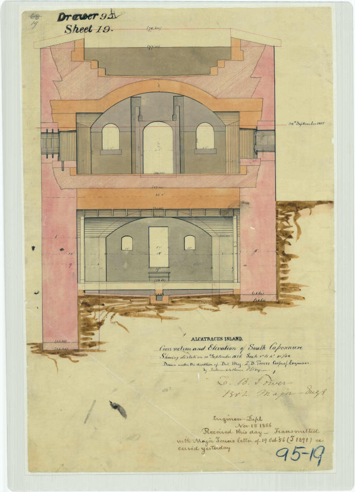
Item 2 – Drawer 95 sheet 2 Map date 1856
Alcatraz Island, cross section and elevation of
south caponniere showing its state on 30 September 1856. Drawn under
the direction of Bvt. Major L.B. Prime, Corps of Engineers. By
Frederick E. Prime, 2nd Lieutenant Engineers (Letter of Major L.B.
Tower, 19 October, 1856)
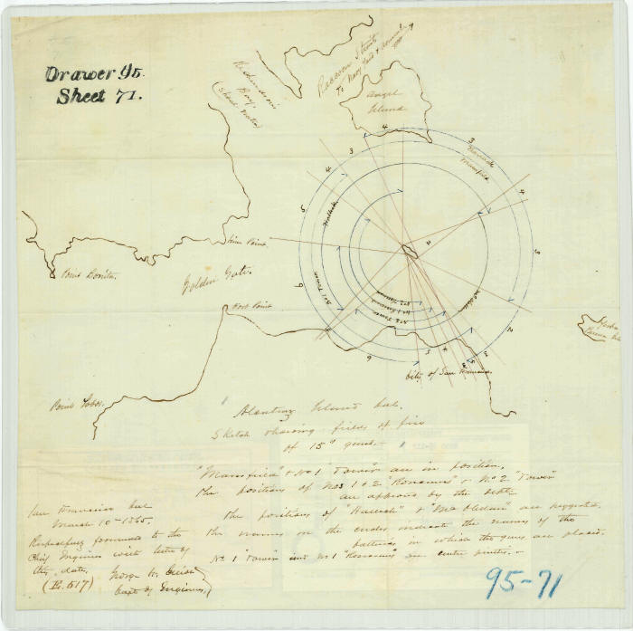
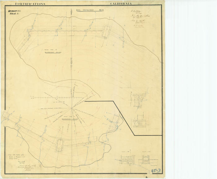
Item 3 –Drawer 95 sheet 71 Map date 1865
Alcatraz Island, California sketch showing
fields of fire of 15 inch guns.
(Letter of Captain G. H. Elliot, 10 March, 1865
– E 517).
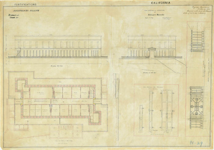
Item 4 – Drawer 95 sheet 29 Map date 1859
Plan sections and elevations of Defensive
Barracks 1 September 1859. Jas B. McPherson 1st Lieutenant of
Engineers.
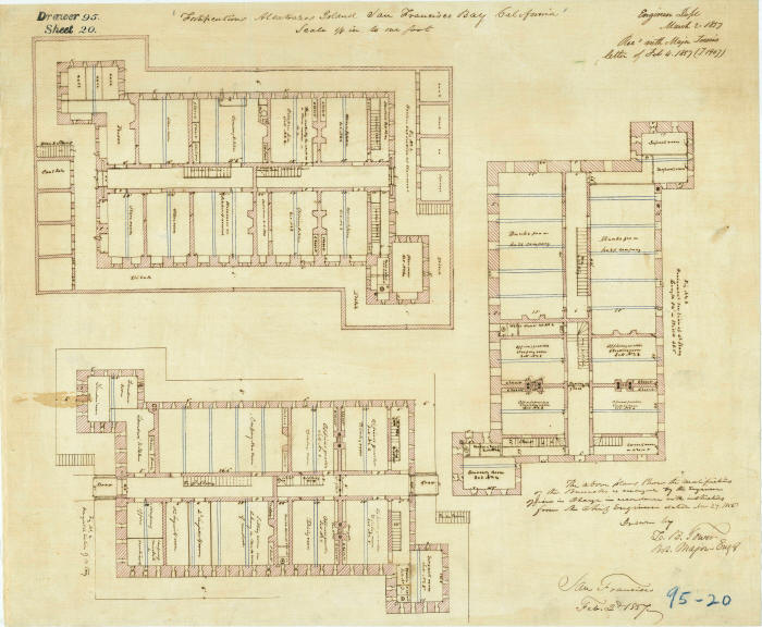
Item 5 – Drawer 95 sheet 20 Map date 1857
Fortifications Alcatrazes Island San Francisco
Bay, California. (Letter of Major L.B. Tower, 4 February 1857 – T
1907).
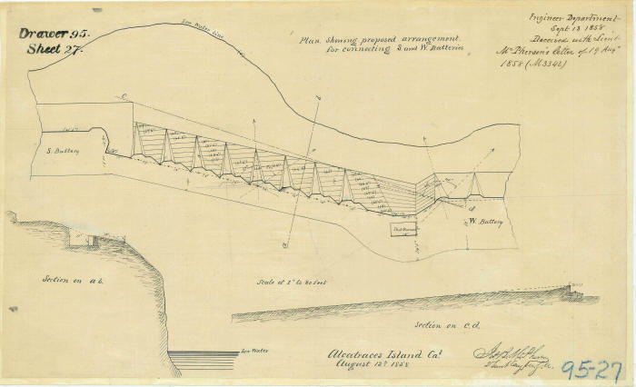
Item 6 – Drawer 95 sheet 27 Map date 1858
Plan showing proposed arrangements for
connecting South and West Batteries
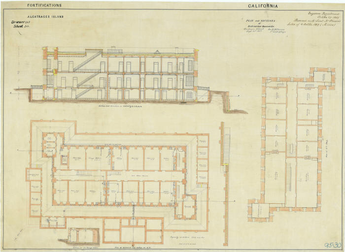
Item 7 – Drawer 95 sheet 30 Map date 1859
Plan and sections of Defensive Barracks
Alcatraces Island 30 September 1859. Jas B. McPherson 1st Lieutenant of
Engineers.
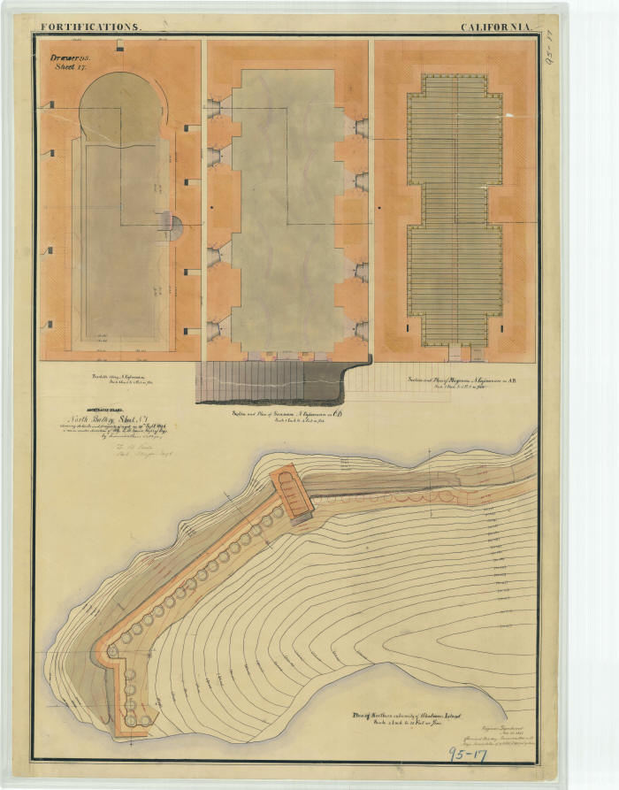
Item 8 – Drawer 95 sheet 17 Map date 1856
Alcatraces Island. North Battery. Sheet number
one showing of work done details and progress on 30 September, 1856.
Drawn under direction of Major L.B. Tower, Corps of Engineers. By
Frederick E. Prime 2nd Lieutenant Engineers.
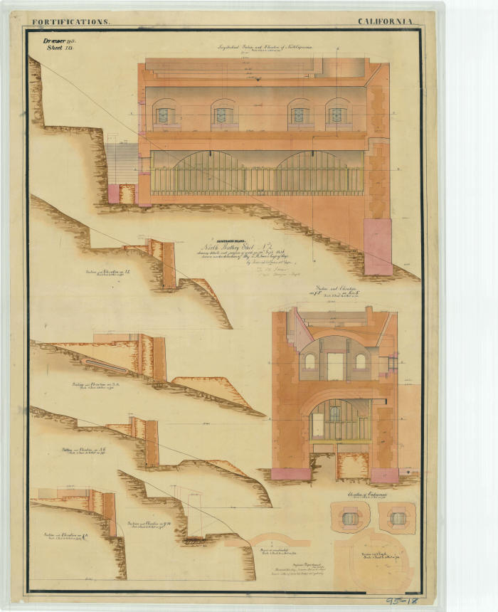
Item 9 – Drawer 95 sheet 18 Map date 1856
Alcatraces Island. North Battery. Sheet number
two showing details and progress of work on 30 September, 1856. Drawn
under the direction of Major L.B. Tower, Corps of Engineers. By
Frederick E. Prime 2nd Lieutenant Engineers.
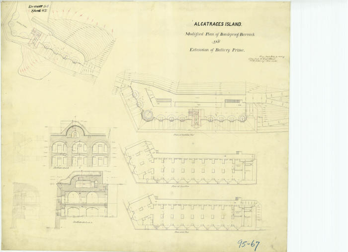
Item 10 – Drawer 95 sheet 67 Map date 1865
Alcatraces Island. Modified plan of Bomb Proff
Barrack and extension of Battery Prime. Engineer Department 9 February
1865.
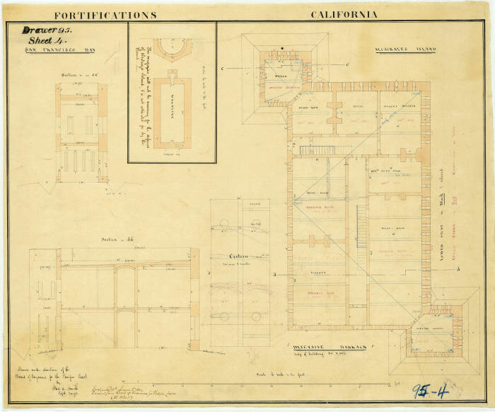
Item 11 – Drawer 95 sheet 4 Map date 1852
Defensive Barrack. Plan & Sections. Drawn
under direction of Board of Engineers for the Pacific Coast by Captain
F.A. Smith
Item 12 – Drawer 95 sheet 3 Map date 1852
Plan and Sections of Battery on North End, and
plan and sections of Battery on South end of Alcatrazes Island
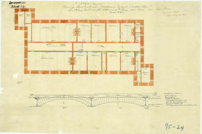
Item 13 – Drawer 95 sheet 24 Map date 1857
Plan of Barracks at Alcatraces Island (Upper
Story)
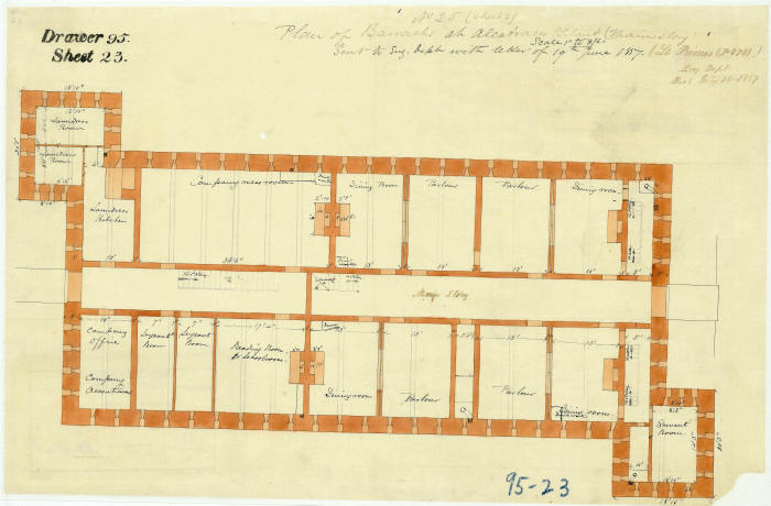
Item 14 – Drawer 95 sheet 23 Map date 1857
Plan of Barracks at Alcatraces Island (Main
Story)
Yes, Alcatraz was spelled three ways on the
maps. I didn’t correct any of the spelling.
Alcatraz, Alcatrazes and Alcatraces.